
SIGNALERT Application
Company dedicated to disaster risk reduction, crisis management, adaptation to climate change and extreme events. Creator of the smartphone participatory mapping application SIGNALERT. SIGNALERT operates worldwide.

An initiative of SIGNALERT SARL
Overview of the project
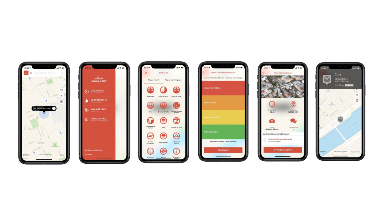
Signalert App is a free smartphone application in 5 languages to share and publish alerts on phenomena witnessed by the user :
- 25 reportable phenomena
- a web platform to exploit alerts and reports shared with the application and to communicate in a top-down manner with the user of the application
- a mass communication system (notification in the application, sms, text to speech) with the population or groups present on the ground
- a connection via API to communicate with other systems
- exploitation of data and measurements from connected objects measuring environmental parameters.
- works worldwide
- In operation (commercial) in Haiti, Tunisia, France
Make the citizen a sensor and actor of resilience to natural disasters and climatic or environmental events.
implementation
2014 -
- The application has intensity scales to qualify the intensity and impact of the observed phenomena
- These scales were developed from 2014 to 2108 with several French public bodies (SCHAPI but also IRSTEA, CEMAGREF now CEREMA, Mountain Land Restoration Service)
Several thousand downloads - Technology sold in Haiti to the civil protection, in Tunisia, in France
- We have connected our system to shared data sensor networks such as Netatmo weather stations or are installing our own networks for early detection of extreme rainfall and early warning of urban runoff
- Operational since 2014 (date of publication of the application on the stores) but constantly evolving with the addition of new languages (Arabic in 2021)
- Several thousand downloads
- In 2015 in Nepal, the application enabled an NGO to locate a large landslide threatening a village that was activated after the two strong earthquakes that the country suffered that year
- The system allows anyone to locate themselves in relation to risk areas (floods in five european countries)
- It will be used in 2021 in a european cross-border crisis simulation exercise
- Hundreds of uses of the application in Haiti during the earthquake of August 2021
The project is supported at the start by BPI FRANCE and SCIENTIPOLE Orsay until 2018 but now autonomous and financially balanced.
About the
organisation
organisation
- Company dedicated to disaster risk reduction, crisis management, adaptation to climate change and extreme events
- Creator of the smartphone participatory mapping application Signalert
- SIGNALERT operates worldwide
Other partners / supporters
- SCHAPI but also IRSTEA, CEMAGREF now grouped in CEREMA,
- Service de Restauration des Terrains de Montagne for the development of the protocols and questions used in the application.
- Several water agencies tested the system in the development phases
- The French High Committee for National Resilience its application in local authorities.